A. Choose the correct answer
1. Which of these is located in the southern part of India?
→ (d) Kerala
2. The Outer Himalayas are also known as:
→ (d) Shivalik
3. Which river is also called Tsangpo?
→ (b) Brahmaputra
4. Where will you find the lagoons?
→ (c) Kerala
5. Which of these crops is grown in the Brahmaputra Valley?
→ (c) Rice
B. Fill in the blanks
1. The northern part of the eastern coastal plain is known as Northern Circar.
2. The Barren Island is situated in the Andaman and Nicobar Islands.
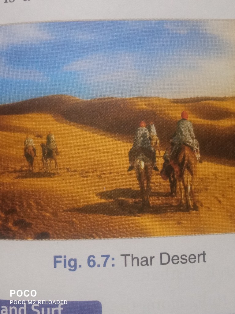
3. The Thar Desert is also known as the Great Indian Desert.
4. Sundarbans is the world’s largest delta.
5. India has 28 states and 8 union territories.
6. Mining is the main occupation of the people living in the Chota Nagpur plateau region.
C. Write T for True and F for False statements
1. F – The Deccan Plateau is also known as Chota Nagpur Plateau in Bihar.
2. T – The Palk Strait lies between India and Sri Lanka.
3. F – West Bengal has a common boundary with China.
4. F – The Eastern Ghats are also known as Sahyadri .
5. T – River Narmada divides the peninsular plateau into two halves.
6. F – The highest mountain range in the world is the Himachal.
D. Very Short Answer Type Questions
1. State the location of India.
Ans: India is located in South Asia and is bordered by the Himalayas in the north, the Arabian Sea in the west, and the Bay of Bengal in the east.
2. Mention the major physical divisions of India.
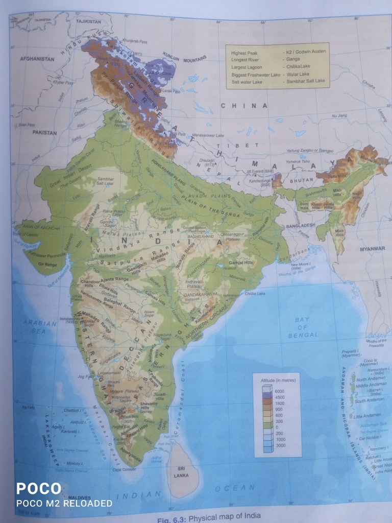
Ans: The major physical divisions of India are: a) The Himalayas b) The northern Plains c) The Peninsular Plateau c) The Indian Desert d) The Coastal Plains e) The Islands.
3. List the two major rivers that drain into the Arabian Sea.
Ans: The Narmada and the Tapti rivers drain into the Arabian Sea.
4. Describe the location and extent of the Deccan Plateau.
Ans: The Deccan Plateau is located in southern India. It extends from the Satpura range in the north to the southern tip of the Indian peninsula.
5. Which delta is formed by the Ganga and the Brahmaputra?
Ans: The Ganga and the Brahmaputra form the Sundarbans Delta.
—
E. Short Answer Type Questions
1. Write a short note on the political divisions of India.
Ans: India is divided into 28 states and 8 Union Territories. Each state has its own government, while Union Territories are governed by the central government. These divisions are based on historical, cultural, and linguistic factors.
2. Compare the Ganga Plain and the Brahmaputra Plain.
Ans: The Ganga Plain is extensive, fertile, and supports a dense population.
The Brahmaputra Plain is narrower and known for its frequent flooding due to heavy rainfall.
3. Write a note on the Malwa Plateau.
Ans: The Malwa Plateau is located in central India, bordered by the Aravalli range in the northwest and the Vindhya range in the south. It is rich in black soil and supports agriculture, especially cotton and wheat.
4. Compare the Western Coastal Plain and the Eastern Coastal Plain.
Ans: The Western Coastal Plain is narrow and lies between the Western Ghats and the Arabian Sea.
The Eastern Coastal Plain is broader and lies between the Eastern Ghats and the Bay of Bengal.
5. Briefly describe the two groups of islands.
Ans: The Andaman and Nicobar Islands lie in the Bay of Bengal and are volcanic in origin.
The Lakshadweep Islands lie in the Arabian Sea and are coral-based.
F. Long Answer Type Questions
1. Explain the geographical extent of India.
Ans: India lies entirely in the Northern Hemisphere. It extends from 8°4′ N to 37°6′ N latitude and from 68°7′ E to 97°25′ E longitude. The Tropic of Cancer (23°30′ N) divides India into two halves. The country has a total area of 3.28 million square kilometers.
2. Write about the mountain ranges of India.
Ans: India is home to several mountain ranges, including the Himalayas in the north, which are the highest and youngest ranges in the world. The Western Ghats and Eastern Ghats are located in the southern peninsula. Other ranges include the Aravalli and the Vindhya.
3. Discuss the features of the Deccan Plateau.
Ans: The Deccan Plateau is a large triangular landmass in southern India. It is bounded by the Western Ghats, the Eastern Ghats, and the Satpura hills. The plateau is rich in minerals and has black soil suitable for agriculture. It slopes gently towards the east.
4. Write a note on the Great Indian Desert with reference to its drainage.
Ans: The Great Indian Desert, also known as the Thar Desert, is located in Rajasthan. It is an arid region with scanty rainfall and extreme temperatures. Rivers in the desert, like the Luni, are seasonal and often disappear into the sand.
5. What are the divisions of the Northern Plains?
Ans: The Northern Plains are divided into three parts:
i) Punjab Plains (formed by the Indus and its tributaries).
ii)Ganga Plains (formed by the Ganga and its tributaries).
iii)Brahmaputra Plains (formed by the Brahmaputra and its tributaries)
G. Higher-Order Thinking Skills
1. Why is India called a peninsula?
Ans: India is called a peninsula because it is surrounded by water on three sides: the Arabian Sea to the west, the Bay of Bengal to the east, and the Indian Ocean to the south.
2. Why is the Ganga Plain suitable for agriculture?
Ans: The Ganga Plain is suitable for agriculture due to its fertile alluvial soil, adequate water supply from the Ganga and its tributaries, and favorable climatic conditions.

Vindhya Mountain Range is an integral part of India’s geographical and ecological framework. Its role as a natural divider, ecological haven, and cultural heritage site underscores its significance. Preserving this range is vital for maintaining ecological balance and supporting the livelihoods of the millions who depend on its resources.
https://www.indianetzone.com/vindhya_range
LikeLiked by 1 person